The threat for snow this weekend appears to be growing for the most part. The bottom line is that many of today's model runs brought the area of low pressure closer to the coast (this means a higher chance of snow). However, considering that the event is still quite a few days out, and there is still model divergence, the prudent call is still a conservative one.
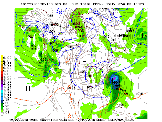
The image displayed to the left is from today's 12z ECMWF (European Weather Model). Notice the large storm system off the east coast of the United States (the tightly packed lines).
This type of signature is an extremely powerful one for east coast storms. Taken exactly as shown, this would produce heavy snowfall for the I-95 corridor and surrounding areas (a lot of precipitation would fall to the southeast of I-95 in our area).
The European model is still only one model, however. The key differences today over yesterday are that some of the other computer models have shifted slightly closer to this solution. There are presently a few solutions that could be the end result, and we will go over them in a minute.
It is possible that the end result will be a compromise between the two different types of solutions currently being printed out by the computer models. Regardless, it is probable that there will be some snow in southeastern parts of the area...the question lies more with how far NW this precipitation reaches.
Compare the image at the right to the image posted above and you will notice that the area of low pressure that could produce snow is farther off the coast (meaning less snow for inland areas).
It is important, however, to note that the image (GFS model) has shifted closer to the ECMWF model portrayed above. If this trend continues, it could signify the threat for snow is increasing.
I do not want to throw out possible accumulation amounts at this time but the time may be drawing close for some early guesses.
The two primary potential scenarios for this storm are as follows -
1) The storm system forms but quickly skirt off the coast and leaves only southeastern-most portions of the area with a little light snow. This solution might even leave our skies mostly sunny.
2) The storm system climbs/crawls up the coast as the more extreme (and consistent) ECMWF model show. This would produce heavy snowfall and gusty winds across a large area (including the I-95 corridor).
There is also a chance a middle ground solution could be reached where light snow would impact the area with the heaviest to the southeast. There is still a lot of time for things to be worked out.
REGARDLESS - This is NO LONGER a Christmas storm system.
STAY TUNED to The Capital Region Pulse for continuing updates. We will be posting another update tomorrow around this time.


No comments:
Post a Comment
Please refrain from using vulgar language when commenting. Also, please post comments that add to the discussion or comment on the article. Please stay on topic!